| Hawaii Highways road photos --
Lanai/Molokai
Below are a dozen road photos from Lanai and Molokai, from my visits
in October 1999 and (Lanai only) November 2001, plus a bonus photo from
Mark and Sue Pelletier's visit to Molokai around the same time I was there.
My photos of Kalawao County, home of the Kalaupapa Settlement,
on the north shore of Molokai are on the following page in this collection,
the Kalawao County photos page.
Note: In case you want more detail, clicking some of the photos
below (for now, just ones from my 2001 trip) will call up enlarged, higher-quality
(less .jpg compression) versions. Those alternate versions have larger
file sizes, so please be patient while they download.
Lanai
 |
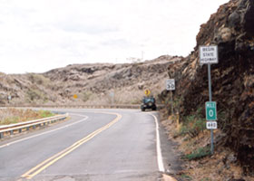 |
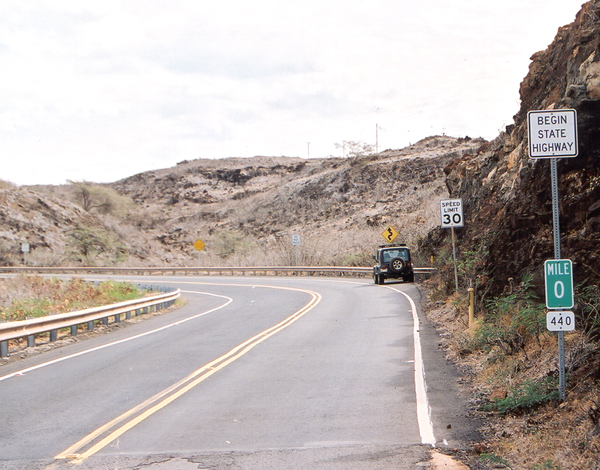
 Here is the
beginning of state route 440, the only state highway on Lanai, at the west
end of the Kaumalapau Highway at the entrance to Kaumalapau Harbor (where
barge deliveries to the island arrive). Above left is the view facing
west as the highway ends. Above right is one facing east, as the highway
begins, indicated not only by the "begin state highway" sign, but also
the zero milepost. (November 2001) Here is the
beginning of state route 440, the only state highway on Lanai, at the west
end of the Kaumalapau Highway at the entrance to Kaumalapau Harbor (where
barge deliveries to the island arrive). Above left is the view facing
west as the highway ends. Above right is one facing east, as the highway
begins, indicated not only by the "begin state highway" sign, but also
the zero milepost. (November 2001)
|
 |
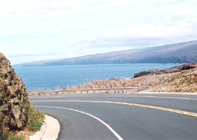 |
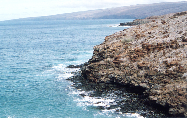
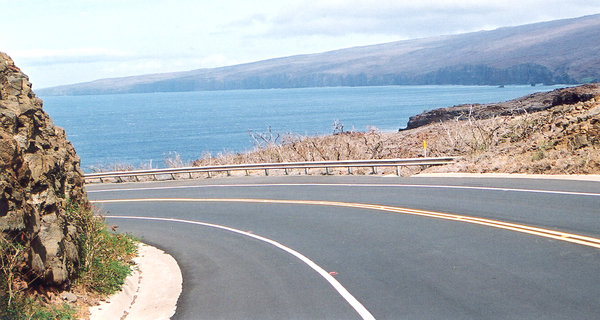
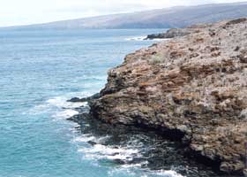
Two views
of Lanai's west coast, the first from the beginning of route 440 where
the above photos were taken, and the second from mile 0.3. (November 2001)
|
|
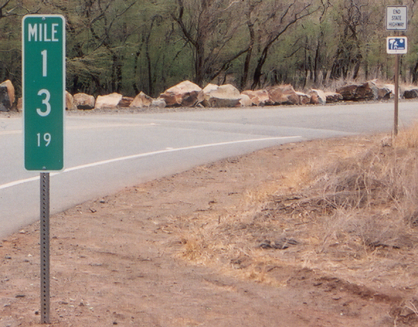
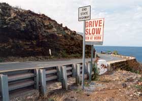
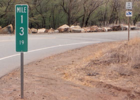
 State route 440 ends
here on Manele Road, at the entrance to Manele Harbor on Lanai's south
coast. The endpoint is marked, per usual practice, by a terminal
milepost reflecting the exact ending mileage of 13.19. Just beyond
the marker in the background is an "end state highway" sign, as well as
a change in the pavement. (November 2001) State route 440 ends
here on Manele Road, at the entrance to Manele Harbor on Lanai's south
coast. The endpoint is marked, per usual practice, by a terminal
milepost reflecting the exact ending mileage of 13.19. Just beyond
the marker in the background is an "end state highway" sign, as well as
a change in the pavement. (November 2001)
|
 |
 |
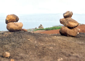
| The stark
landscape of the Garden of the Gods rock formations (said to be spectacular
in the afternoon sun, only there wasn't any on my visits to the island),
from the unpaved, unnumbered Polihua Road northwest of Lanai City. (November
2001) |
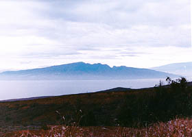
The west side
of Maui, from the overlook at mile 3.2 on Keomuku Road (old county route
430) in northeastern Lanai. (October 1999) |
Molokai |
 On Kamehameha V Highway
(state route 450) on the southeast shore of Molokai, across the road from
One Ali'i Beach Park (alas, beaches are not really Molokai's strong suit),
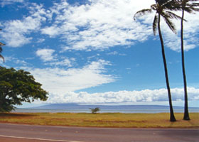
and across the strait from the north coast of Lanai. (October 1999) On Kamehameha V Highway
(state route 450) on the southeast shore of Molokai, across the road from
One Ali'i Beach Park (alas, beaches are not really Molokai's strong suit),
and across the strait from the north coast of Lanai. (October 1999) |
|
 |
 |
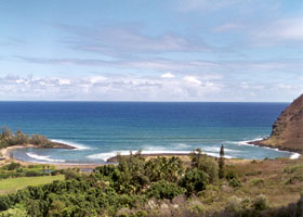
Keaina Bay,
along a curvy stretch of route 450 near its end on Molokai's east shore.
(October 1999)
|
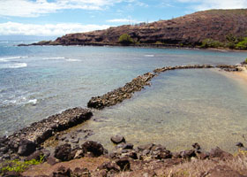
Nearby, a
traditional fishpond, used to trap and hold fish for later consumption.
(October 1999)
|
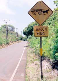
This "Wagon Xing" sign is also on route 450, near mile 15 at Moloka'i Horse and Wagon
Ride between Kalua'aha and Puko'o. (June 2005) |
|
 |
 |
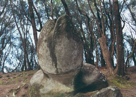
| Phallic Rock,
in a state park on the north shore of Molokai, a short hike from the end
of Kalae Highway (state route 470). Hawaiian women on the island traditionally
stayed here overnight to pray for fertility. A sign at the site says the
rock is a mostly natural formation, but the native Hawaiians did make a
few "enhancements." (October 1999) |
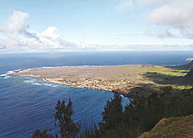
In the same
state park is an overlook of the Kalaupapa Peninsula. It is best known
for its history as a place of quarantine for Hansen's Disease ("leprosy")
patients (the quarantine has been lifted, but some patients chose to remain).
The Kalaupapa Peninsula is also in a separate county (Kalawao County) from
the rest of Molokai (part of Maui County), isolated by cliffs more than
a quarter-mile high, and with no motor vehicle land access (only a mule
trail). See the following Kalawao County photos page for more. (October 1999)
|
Go to the previous or next parts of the Hawaii Highways road photos collection:
or directly to other parts:
Overview · Introduction
· Interstate H-3 · Interstate H-1 · Other Freeways
Other Oahu South · Other
Oahu West · Other Oahu East · Kuhio Highway
Other Kauai · Hana
Highway · Piilani Highway · Kahekili Highway
Saddle Road · Observatories Roads · Lava Closures · Red Road
Waipio Valley · Other Big Island
or to other sections of the Hawaii Highways site:
Comments, etc.? Please e-mail me.
© 1999-2006 Oscar Voss. |