| Hawaii Highways road photos -- Kalawao County
More than a dozen photos below, and links to still more
photos and other sources, cover Kalawao County (the Kalaupapa Settlement)
on Molokai. They aren't particularly road-oriented, but are included in
the Hawaii Highways road photos collection anyway to provide complete coverage
of all five of Hawaii's counties. Also, Kalawao County is an important
part of Hawaiian history, as a former place of exile for those diagnosed with
Hansen's Disease ("leprosy"). It also is the site of the legendary works caring for the exiles, of Father
Damien de Vuester in the late 19th century and Mother Marianne Cope who carried on Damien's work after his death. Both were recently
canonized as Catholic saints, Damien in 2009 and Marianne in 2012.
Except as otherwise noted, all the photos below are
my own, from my October 1999 and June 2005 visits to Molokai.
Kalawao County is on the Kalaupapa Peninsula on the
north shore of Molokai. It is a separate county from the rest of Molokai
(which is part of Maui County, along with Lanai and uninhabited Kahoolawe),
even though many maps don't show Kalawao as a separate county. (For those
of you who've heard that Kalawao County isn't for real, the FAQs will set you straight on that point, as well as provide other interesting information about the county.) It is isolated from the rest of Molokai
by sea cliffs over a quarter-mile high, with the only land access a tricky
mule trail (you can hike it too, but watch out for all those "mule apples"!).
While Kalawao County has few roads and no state or other numbered highways, it has other unique features of interest to "road geeks" (particularly those whose "geekery" includes "county-counting," or trying to visit
as many counties as possible -- and Kalawao is one of the harder ones to clinch). Kalawao County has the smallest land area and second-smallest population of any county in the U.S., and is also the only U.S. county where entry is prohibited by law except with state permission (which most tourists can easily obtain, but only through an authorized tour operator).
NOTE: In case you want more detail, clicking any photo below will call up an enlarged, higher-quality (less .jpg compression) version. Those alternate versions have larger file sizes, so please be patient while they download.
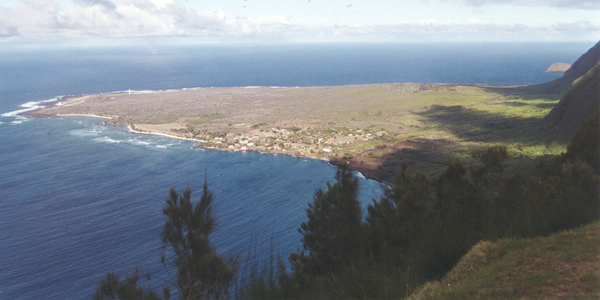
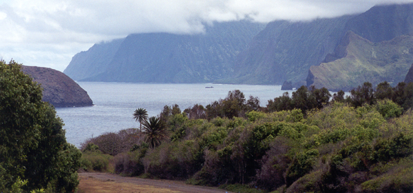
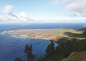
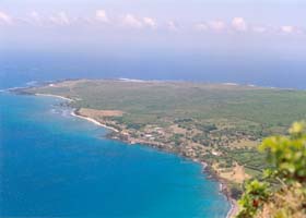
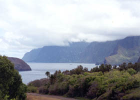
 An overview
of Kalaupapa village and the rest of Kalawao County, from an overlook at
the end of state route 470 in Palaau State Park. (October 1999) An overview
of Kalaupapa village and the rest of Kalawao County, from an overlook at
the end of state route 470 in Palaau State Park. (October 1999) |
|
|
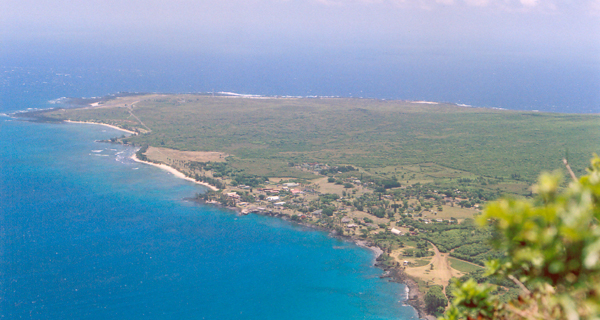
 A closer view of the Kalaupapa Peninsula, this one from the mule trail down to the peninsula, where it starts its descent down the cliff. (June 2005) A closer view of the Kalaupapa Peninsula, this one from the mule trail down to the peninsula, where it starts its descent down the cliff. (June 2005) |
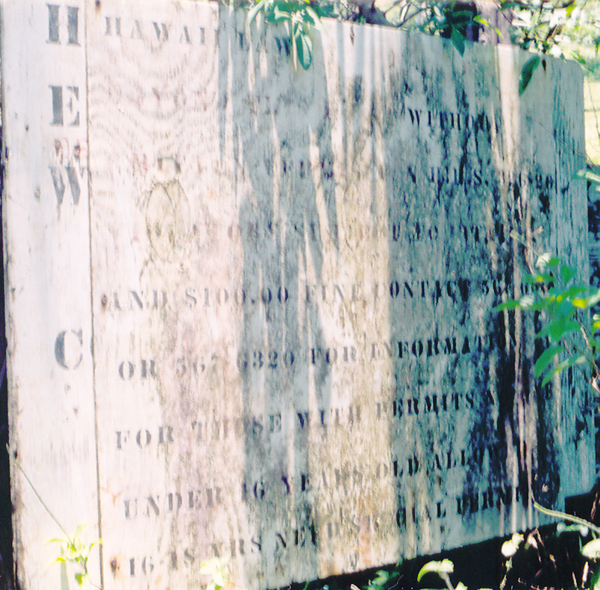
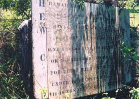
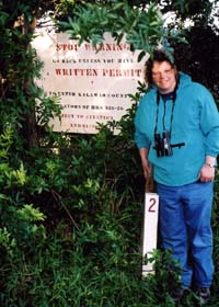
This very faded old sign was the first of the "unwelcome" signs I saw on the mule trail down to Kalawao County. As far as I know, it was a few hundred feet uphill from the county line. The sign set forth an older (and still largely accurate) version of the unique prohibition on visiting the county without prior state permission. Click here, or cursor over the photo, for what I could make out of the words on the sign. (June 2005)
|
|
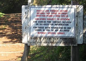
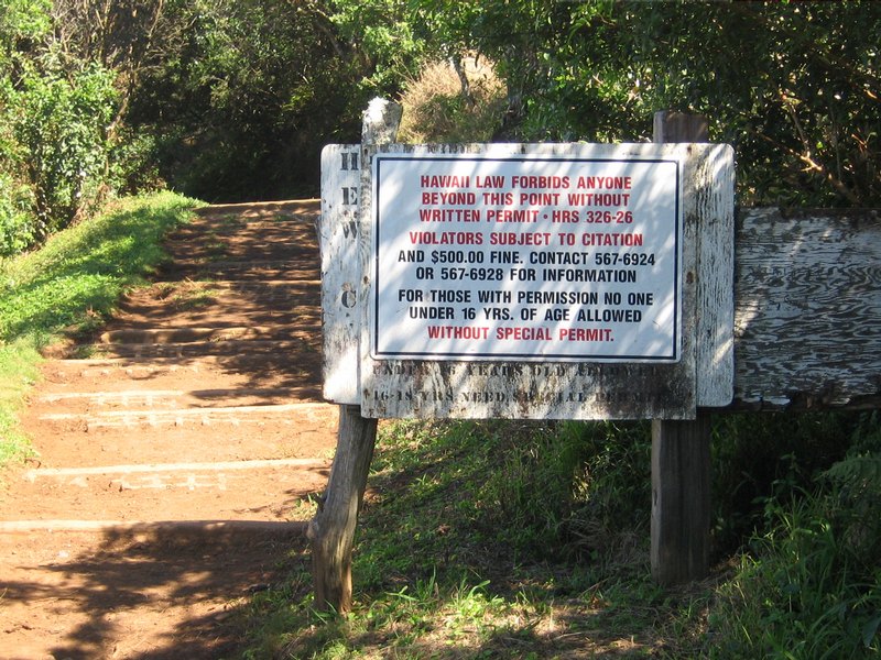
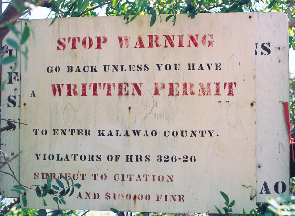
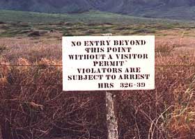
| More recently, the faded old sign above was covered by a brand-new one, with an updated warning. The fine for getting caught crossing the county line without a permit is higher than shown on the old signs, but the former flat ban on entry by persons under 16 has been replaced by a "special permit" requirement. Those special permits may be issued only for young relatives of Kalaupapa Settlement patients to see them on family visits, and are not available to tourists. (February 2007, courtesy of Aaron Stene)
|
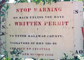
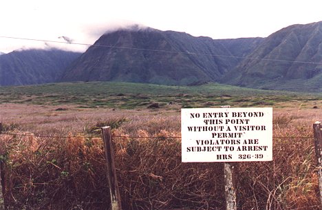
 This warning sign is a few hundred feet farther down the mule trail than the ones above, about two miles up from the bottom of the trail and about a half-mile down from state route 470, just before the trail takes a sharp right turn down the side of the cliff above the village. As far as I know, this sign is right at or close to the Kalawao County line. (Photo above left June 2005; photo above right March 2004, by B. Bessken, courtesy of V. Naylor who is standing next to the sign) This warning sign is a few hundred feet farther down the mule trail than the ones above, about two miles up from the bottom of the trail and about a half-mile down from state route 470, just before the trail takes a sharp right turn down the side of the cliff above the village. As far as I know, this sign is right at or close to the Kalawao County line. (Photo above left June 2005; photo above right March 2004, by B. Bessken, courtesy of V. Naylor who is standing next to the sign)
|
|
|
A earlier version of the sign, this one at the airport exit. (November 1992, courtesy of David Flack) |
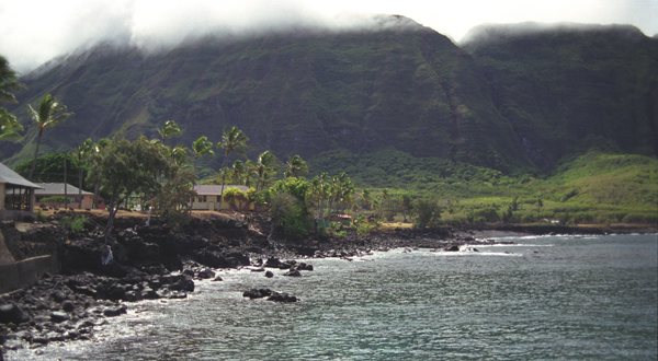
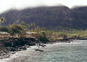
| The Kalaupapa
Settlement, at the foot of the 1600'-high sea cliffs that block land access
from the rest of Molokai, and surrounded by rough and shark-infested waters.
Its isolation made Kalaupapa the perfect place for the Kingdom of Hawaii to exile Hawaiians diagnosed with Hansen's Disease, beginning in 1866 in the reign of King Kamehameha V. Hansen's Disease can now be treated and made noncontagious, and in 1969 patients were allowed to leave (and no new patients were admitted). However, many chose to stay, and about two dozen of them still remain. |
 |
Even though the quarantine has been lifted, and the
Settlement is now a national historical park, state permission to visit
is still required, to protect the privacy and dignity of the remaining
patients. Tourists may visit only on escorted official tours (no tours on Sundays, and no children allowed). (October 1999)
|
 |
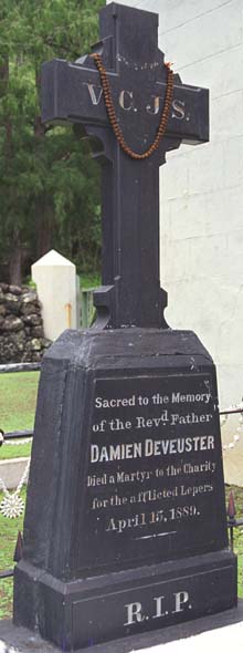 |
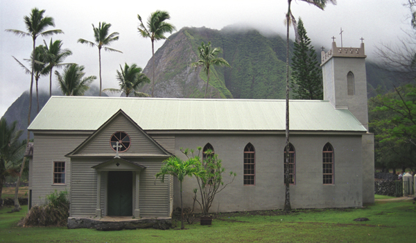
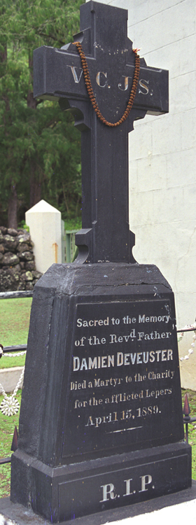
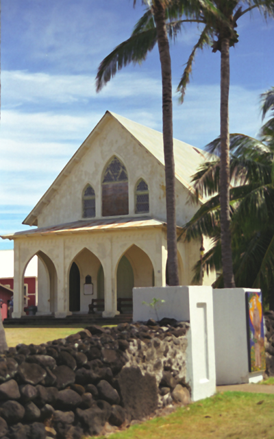
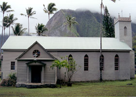
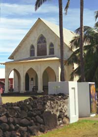
 St. Philomena Church (above) in Kalawao, the original settlement for Hansen's Disease patients, east of Kalaupapa. This is where St. Damien held services, and was buried (right -- his body was later returned to his native Belgium, but his right hand was later re-buried here). Catholic services are now held in St. Francis Church in Kalaupapa (below). (All photos October 1999) St. Philomena Church (above) in Kalawao, the original settlement for Hansen's Disease patients, east of Kalaupapa. This is where St. Damien held services, and was buried (right -- his body was later returned to his native Belgium, but his right hand was later re-buried here). Catholic services are now held in St. Francis Church in Kalaupapa (below). (All photos October 1999) |
|
 |
 |
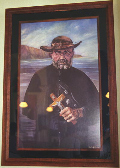
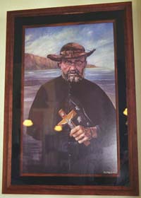
Saint Damien,
just before his death in 1889 (of Hansen's Disease), depicted in a painting hung
in St. Francis Church in Kalaupapa. He came to Kalaupapa in 1873 to care
for the exiles, who until then had been largely left to fend for themselves
with little aid and no treatment. His efforts made him legendary in the
islands, and the Catholic Church formally declared him a saint in ceremonies in Rome on October 11, 2009. (October 1999)
|
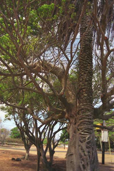
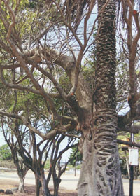
In Kalaupapa,
a "mixed marriage" of a banyan tree wrapped around a palm tree. (October 1999)
|
 |
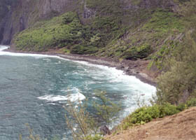 |
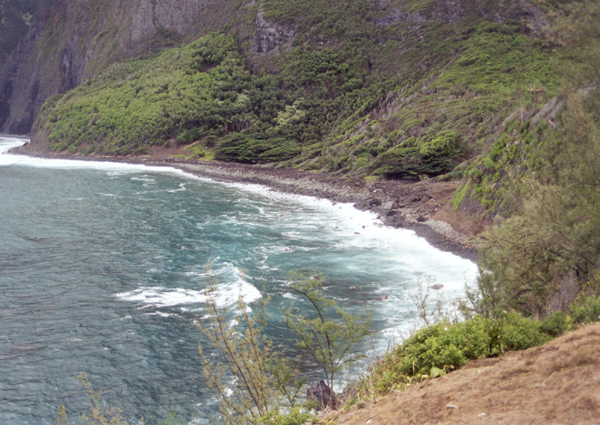
Overview of
Kalawao Cove, where exiles were unceremoniously dumped onshore in the first
years of the settlement. (October 1999)
|
A closer view
of Kalawao Cove. (October 1999) |
 |
 |
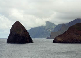
| The shark's
tooth-shaped Okala Island on the east side of Kalawao Cove. (October 1999) |
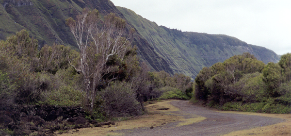
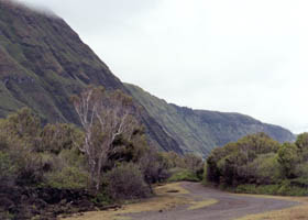
The dirt road
from Kalawao Cove back to Kalaupapa. (October 1999) |
Some other sites and sources:
Ham radio operator
David Flack took some excellent pictures of Kalawao County on a 1992
group visit there with his fellow ham operators. These include some road
photos I wish I'd taken, such as one of a sign prohibiting entry into
the county without a state permit (shown above).
Ed Wilson also took some
photos (including street scenes) of the Kalaupapa area on his visit
the month after I went there.
The VisitMolokai site
has many photos of the Kalaupapa area, as well as one of the mule trail
down to the settlement, and a good brief summary of the area's history.
The Pixel Pot site includes some
more photos of Kalawao County, including a dirt road between Kalaupapa
and the old Kalawao village.
Molokai Mule Ride, Inc. ran the
mule ride tour I took down the cliff to Kalaupapa, and its site is informative
as well as promotional.
National Park Service - Kalaupapa
National Historical Park also has useful information about the Kalaupapa
Settlement's history, as well as visitor information.
J.D. Bisignani, Maui Handbook (5th edition 1999), is one of
the Moon Travel Handbooks which were my main trip planning reference for
my trips to Hawaii. Its eloquent summary of the Kalaupapa Settlement's
history was what led me to add the settlement, and the associated mule
ride, to my itinerary.
Go to the previous or next parts of the Hawaii Highways road photos collection:
or directly to other parts:
Overview · Introduction
· Interstate H-3 · Interstate H-1 · Other Freeways
Other Oahu South · Other
Oahu West · Other Oahu East · Kuhio Highway
Other Kauai · Hana
Highway · Piilani Highway · Kahekili Highway
Other Maui · Observatories Roads · Lava Closures · Red Road
Waipio Valley · Other Big Island
or to other sections of the Hawaii Highways site:
Comments, etc.? Please e-mail me.
© 1999-2007, 2009, 2012 Oscar Voss. |