| Hawaii Road
Sign Photos by Oscar Voss (page
3 of 3)
This three-page photo collection is a subset of the Road
Photos collection for my Hawaii Highways site,
focusing on road signs I found throughout the islands on my trips there
in autumn 1999, May 2000, November 2001, and May/June 2005, as well as several others
photographed by other people (all photos are mine unless otherwise noted). These include not only examples
of standard signage, but also some variants thereof, and also some of the
more interesting road signs in the state.
Page 1 focused on route markers, milemarkers, etc. for state and county highways in Hawaii. Page 2 covered signage on Hawaii's Interstates. Page 3 below covers other kinds of road signs, both those common throughout the islands and some of the more unique signs seen here and there.
NOTE: In case you want more detail, clicking some of the
photos below will call up enlarged, higher-quality (less .jpg compression)
versions. Those alternate versions have larger file sizes, so please be
patient while they download.
|

Page 2: Interstate signage
or return to Page 1: route markers, milemarkers, etc.
|
 |
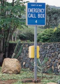 |
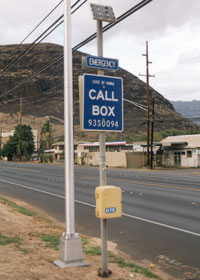
 Hawaii has
emergency call boxes scattered along its Interstates and some other major
routes. The call box signs resemble those in California. The main
difference is that while California's specify the county where the call
box is located, Hawaii's instead show who maintains the call box ("State
of Hawaii" if it's Hawaii DOT, as with the sign above left along state
route 93 on Oahu, or "County of ___" for county-maintained boxes, as with
the sign above right near the west end of state route 340 in northwest
Maui). County-maintained call boxes also lack the code at the bottom indicating
their location by route, traffic direction, and mile (times 10). (Both
photos November 2001) Hawaii has
emergency call boxes scattered along its Interstates and some other major
routes. The call box signs resemble those in California. The main
difference is that while California's specify the county where the call
box is located, Hawaii's instead show who maintains the call box ("State
of Hawaii" if it's Hawaii DOT, as with the sign above left along state
route 93 on Oahu, or "County of ___" for county-maintained boxes, as with
the sign above right near the west end of state route 340 in northwest
Maui). County-maintained call boxes also lack the code at the bottom indicating
their location by route, traffic direction, and mile (times 10). (Both
photos November 2001)
|
 |
 |
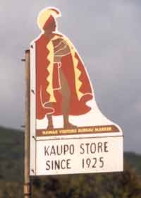
Hawaii Visitor
Bureau signs like this highlight both major and minor places of interest
along both state and county highways, as with this sign along an unpaved
stretch of county route 31 south of the Haleakala volcano on Maui. (November
2001)
|
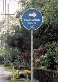
These "evacuation
route" signs are particularly common in areas prone to tsunamis ("tidal
waves"), as here near the Hilo waterfront. (November 2001) |
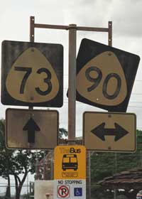
 In Pearl
City, a bus stop marker for Oahu's "TheBus" system, by far the best bus
system on the islands, and the only one with service frequent and extensive
enough to be a plausible alternative for most tourists to renting a car.
The route signs above the bus stop marker (which have since been
removed) are outdated -- the cross street
identified as route 90 long ago became route 99 (part of the Kamehameha
Highway), while the roads identified as route 73 (Waimano Home Road/Lehua
Avenue) have long been removed from the state highway system and are now
unnumbered county roads. (November 2001) In Pearl
City, a bus stop marker for Oahu's "TheBus" system, by far the best bus
system on the islands, and the only one with service frequent and extensive
enough to be a plausible alternative for most tourists to renting a car.
The route signs above the bus stop marker (which have since been
removed) are outdated -- the cross street
identified as route 90 long ago became route 99 (part of the Kamehameha
Highway), while the roads identified as route 73 (Waimano Home Road/Lehua
Avenue) have long been removed from the state highway system and are now
unnumbered county roads. (November 2001)
|
|
 |
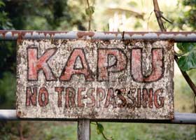 |
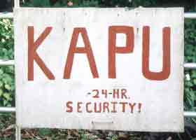
"Kapu" is
Hawaiian for "forbidden." On a roadside sign, it means "no trespassing."
(Both photos November 2001)
|
 |
 |
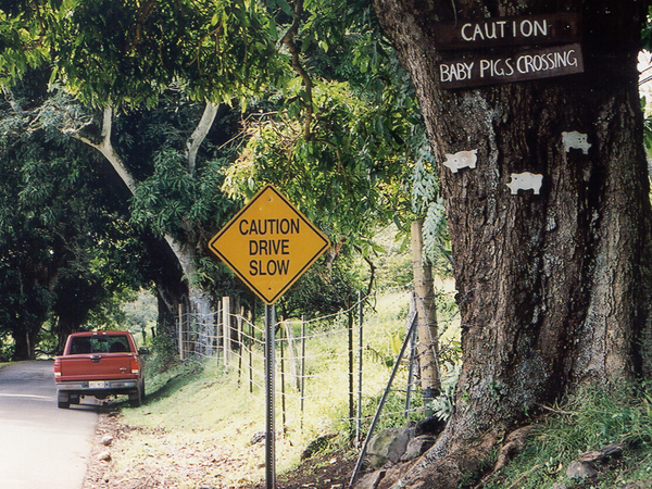
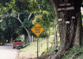
| The famous
unofficial "Baby Pigs Crossing" sign, on this tree along the county-maintained
portion of the Hana Highway south of Hana (part of county route 31), at
mile 45.4 southbound between Hamoa and Kipahulu. (November 2001) |
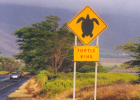
This "Turtle
Crossing" sign was on North Kihei Road (state route 310) on the south Maui
coast, on a major turtle migration path between the shore and the Kealia
Pond wildlife refuge. The sign was no longer there when I revisited Maui in mid-2005. (March 1999, photo courtesy of Mark
and Sue Pelletier, contrast enhanced on sign)
|
Just after the entrance to Maui's Haleakala National Park, this
"Nene Crossing" sign alerts visitors to watch out for those birds on Haleakala
Crater Road all the way to the summit. The nene are a goose species unique
to Hawaii, threatened by among other things their unfortunate habit of
walking across highways without looking both ways first -- as one local
wag put it, nene are not exactly the Einsteins of the bird world. (May 2005)
|

|
|
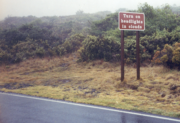
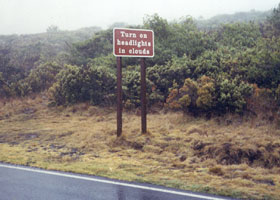
 Also in Haleakala National
Park, this National Park Service sign (here, on the downhill side of Haleakala
Crater Road) reminds travelers to use their lights when the clouds drop
below the summit, like on this foggy day. (January 1999, photo courtesy
of Teresa Frechette) Also in Haleakala National
Park, this National Park Service sign (here, on the downhill side of Haleakala
Crater Road) reminds travelers to use their lights when the clouds drop
below the summit, like on this foggy day. (January 1999, photo courtesy
of Teresa Frechette) |
 |
 |
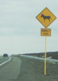
The Big Island's Queen
Kaahumanu Highway (part of state route 19), north of Kailua-Kona's airport,
passes through the stomping grounds of a herd of wild donkeys. (October
1999, courtesy of Mark
and Sue Pelletier)
|
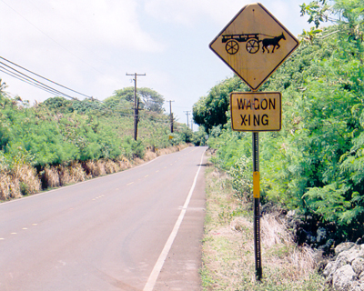
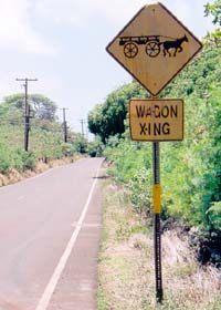
On rural Molokai, near mile 15 on Kamehameha V Highway (state route 450), this "Wagon Xing" sign helps a local wagon tour operator take tourists across the highway. (June 2005)
|
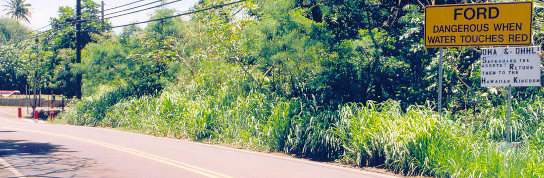 |
Also on the Kamehameha V Highway is this warning sign (far right) for a ford up ahead (far left), with red markings on the white concrete posts at the crossing to tell motorists if the water is too high to safely cross to the other side. This is one of two major fords on Molokai (the other on state route 460 just west of the island's largest town Kaunakakai -- there are none on any other state highway in Hawaii, except state route 580 on Kauai ends at a ford), both unfortunately in places where there are no alternate stream crossings, so floods could conceivably cut off western and/or eastern Molokai from Kaunakakai. Beneath the official sign is an unofficial one, supporting the return of certain state-administered lands to a restored Hawaiian kingdom. About half of Molokai's population is native Hawaiian, and the island is a stronghold of support for Hawaiian sovereignty. (June 2005)
|
|
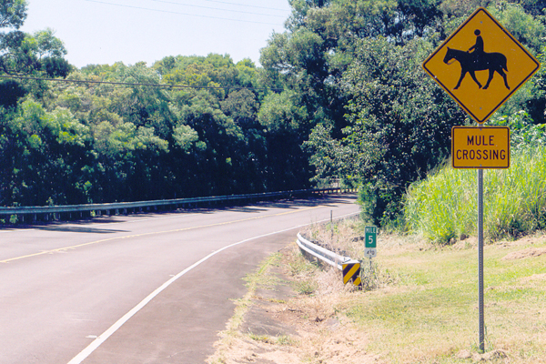
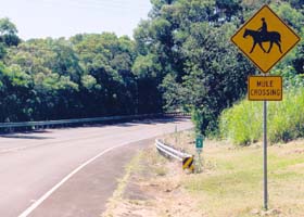
The mules crossing here, near the north end of the Kalae Highway (state route 470) on Molokai, are for the daily (except Sundays and some holidays) Molokai Mule Ride tour taking tourists on the long cliffside trail down to the Kalaupapa Settlement. (June 2005)
|
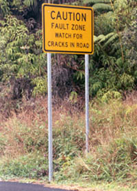
| On state
route 11 as it passes upslope from the Big Island's Kilaeua volcano. This
happens to be relatively safe (for the southern half of the Big Island)
from lava flows, since it's uphill from the Kilauea caldera, and lava from
the Mauna Loa volcano above usually flows well away from the road. But
the road is still vulnerable to damage by the occasional earthquakes from
both volcanoes. (May 2000) |
|
|
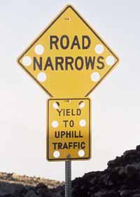
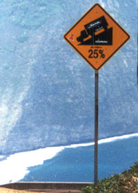
On unnumbered
John A. Burns Way to the summit of the Big Island's Mauna Kea (third highest
auto road in the United States, ascending to 13780 feet), most of the road
signs are "swisscheesed" like this to help them withstand high winds sometimes
blowing around the mountain. Like the signs below on the even steeper Waipio
Valley access road, the sign here advises motorists to yield to uphill (rather than, as usual, downhill) traffic,
so that climbing vehicles can maintain momentum on the long 15% grade. (November 2001) |
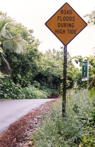
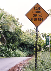
County route 137 (a/k/a
the "Red Road"), along the southeastern Puna coast of the Big Island, at
one very low-lying point sometimes is underwater at high tide. The road
was originally built on high ground, then the ground -- along with the
rest of the Puna coast -- suddenly sank a few feet in 1975. (November 2001) |
|
|
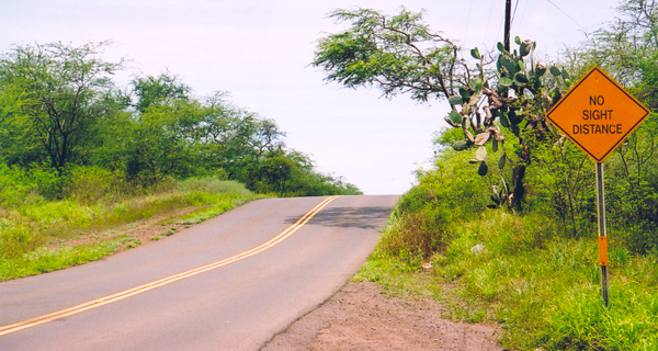
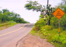
"Limited Sight Distance" is a common sign, but this sign takes that message one step further, on this particularly narrow and rolling stretch of Makena Road in south Maui north of La Perouse Bay. (May 2005) |
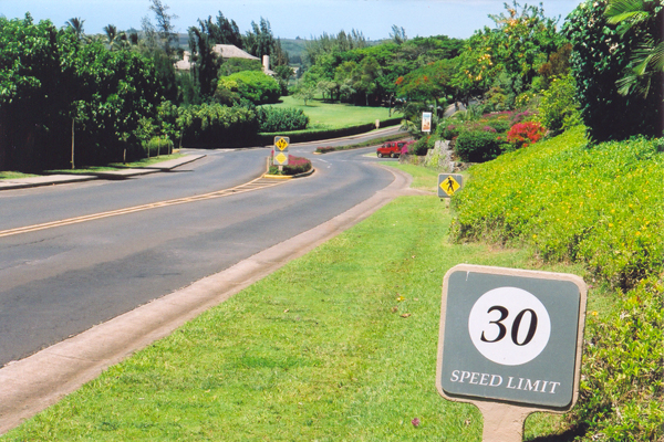
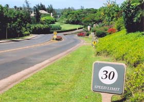
Lower Honoapiilani Road through the upscale Kapalua on Maui (former route 30) is as far as I know still a public road, but some of the signage like this nonstandard speed limit sign is more typical of private roads not subject to the uniform signage requirements of the Manual of Uniform Traffic Control Devices. (May 2005)
|
|
 |
 |
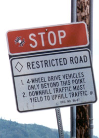
| Two warning
signs at the top of the incredibly steep and narrow Waipio Valley access
road, about 0.7 mile long, at the west end of state route 240 on the Big
Island's north shore. The road is paved, but 4x4 with low range
is a must, else you'll likely burn up your brakes on the way down, and
if you reach the bottom in one piece you won't have enough power to climb
back out again -- the one tow company with a truck powerful enough to tow
cars out of the valley will charge you a small fortune, and your AAA card
won't be worth squat, either. With the steep grade, uphill vehicles may not
be able to regain their momentum if they have to stop, so downhill vehicles
are required to yield, using one of several paved pullouts. (Both photos October 1999) |
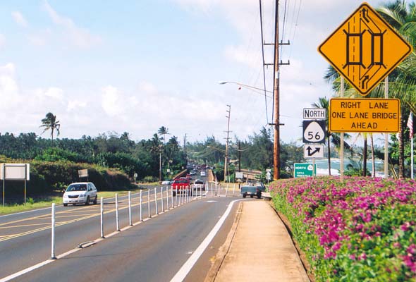 |
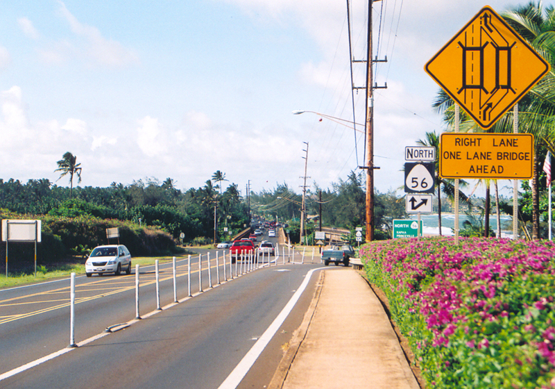
On the Kuhio Highway (state
route 56) on Kauai north of Lihue, near mile 5.8, the northbound lanes of
the highway split, to cross the Wailua River (Hawaii's only navigable river)
on both part of the main two-lane highway bridge, and a parallel old cane haul bridge converted to provide an additional lane northbound. Hawaii DOT is considering widening the one-lane bridge, as part of widening this stretch to four lanes total. (June 2005)
|
 |
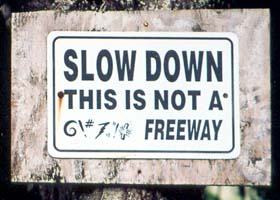 |
I guess there have been problems with speeders on this dirt road, Ana Eke Road, branching off near the end of the Kuhio Highway (at this point state route 560), just east of the main Wainiha River crossing, to prompt this very unofficial caution sign. (Both photos June 2005)
|
Page 2: Interstate signage
or return to Page 1: route markers, milemarkers, etc.

|
| © Oscar Voss 1999-2001, 2003-2007. Last revised March 2007.
Comments, etc.? Please e-mail me. |