| Puerto Rico road trip photos - Page 1 of 2
Unless otherwise noted, all of the following photos are my own, from
a quick trip to Puerto Rico over Labor Day weekend 2002. Most of the commentary
is also my own, but Michael González, who lives in western Puerto
Rico, provided helpful comments on an earlier version of these pages, some
of which are incorporated below. Thanks also to Nelson Rivera, who pointed out that
I had unknowingly taken photos of signs for three of Puerto Rico's five official tourist routes
(new enlargements of those signs have been added below).
This two-page collection begins with a page of road signs and license
plates. The second page focuses
on the termini of Puerto Rico's unsigned Interstates (PRI-1 through PRI-3),
as well as some other highway junctions.
|
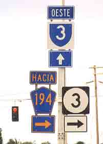
 This sign
assembly, near Fajardo in northeastern Puerto Rico, shows the three current
varieties of route shields used on non-toll highways. The blue-on-white
shield, with white numbering, on top is used for the island's primary free
highways. ("Oeste" means "west.") The blue cutout-style shield, with
gold munbering, on the lower left is used for roads other than highways
connecting municipalities. ("Hacia" means "to.") The white-on-black shield,
with black numbering, on the lower right seems to be reserved for local
access routes or other minor highways; often the shield is oval, to accommodate
3- or 4-digit route numbers. Sometimes different parts of a route
are classified and signed differently, as here where westbound route 3
is a major route from Fajardo to San Juan, while the highway in the other
direction toward Humacao has been bypassed by a new autopista (toll road). This sign
assembly, near Fajardo in northeastern Puerto Rico, shows the three current
varieties of route shields used on non-toll highways. The blue-on-white
shield, with white numbering, on top is used for the island's primary free
highways. ("Oeste" means "west.") The blue cutout-style shield, with
gold munbering, on the lower left is used for roads other than highways
connecting municipalities. ("Hacia" means "to.") The white-on-black shield,
with black numbering, on the lower right seems to be reserved for local
access routes or other minor highways; often the shield is oval, to accommodate
3- or 4-digit route numbers. Sometimes different parts of a route
are classified and signed differently, as here where westbound route 3
is a major route from Fajardo to San Juan, while the highway in the other
direction toward Humacao has been bypassed by a new autopista (toll road).
|
 |
|
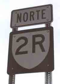
 A variant
on the primary routes shield for urban avenues, that I sometimes saw around
Mayaguez and Ponce. This example is from the route 2 business route
(the "R" is for "ramal" or branch) northbound through downtown Mayaguez,
east of the bypass that now carries PR-2. A variant
on the primary routes shield for urban avenues, that I sometimes saw around
Mayaguez and Ponce. This example is from the route 2 business route
(the "R" is for "ramal" or branch) northbound through downtown Mayaguez,
east of the bypass that now carries PR-2.
For more information on current route signage on Puerto Rico's highways,
see the Nuevo
Rotulación page (in Spanish, works best with Internet Explorer)
on the Departamento de Transportación
y Obras Públicas website.
|
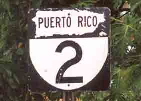
This older type of
route shield was apparently used on all types of non-toll highways, until
the introduction in 1999 of the new system outlined above. Many such signs
remain, often on the same routes and route segments where the newer-style
shields above are posted, as here on PR-2 near Aguadilla.
|
|
 |
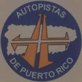 |
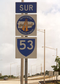
 One of the
newest of Puerto Rico's toll roads ("autopistas"), PR-53 from Fajardo south
("sur") toward Humacao and eventually along the southeast coast, is signed
with the standard blue-and-white major route shield, supplemented with
the "Autopistas de Puerto Rico" emblem. One of the
newest of Puerto Rico's toll roads ("autopistas"), PR-53 from Fajardo south
("sur") toward Humacao and eventually along the southeast coast, is signed
with the standard blue-and-white major route shield, supplemented with
the "Autopistas de Puerto Rico" emblem.
|
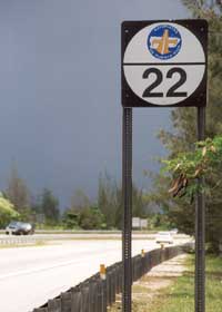
The older autopistas
(PR-22 west of San Juan along the north coast, and PR-52 south from San
Juan through the mountains to Ponce on the south coast) are signed like
this. This photo was taken on eastbound PR-22, after a toll plaza west
of Barceloneta.
|
|
|
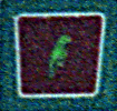
Some major tourist routes have not only route number markers, but also scenic route markers. The photos above are heavily enlarged (and so rather grainy, even with digital enhancement) excerpts from my photo of the small brown signs on the overhead sign assemblies for northbound PR-18 at its junction with westbound PR-22, shown on the next page. The photo above left is for the "Parrot Route" (Ruta Cotorra Puertorriqueña), which follows PR-22 and PR-2 to Mayaguez at the western end of the island. The photo above right shows markers for both the "Tree Route" (Ruta Flamboyáns), from Humacao in eastern Puerto Rico into downtown San Juan on PR-30, PR-52, and PR-18, and the "Horse Route" (Ruta Caballo de Paso Fino), which follows PR-2, PR-52, and PR-18 from Mayaguez through Ponce into downtown San Juan. Two other tourist routes with signs I did not photograph are the "Frog Route" (Ruta Coquí), from Humacao through Fajardo in northeastern Puerto Rico then west to San Juan over PR-3 and PR-26, and the "Panoramic Route" (Ruta Panorámica) over multiple secondary highways along the spine of the mountain range crossing the island from west to east. See the tourist route page of the Puerto Rico-Boriken tourist information site for more details on these scenic routes and their signage.
|
 |
 |
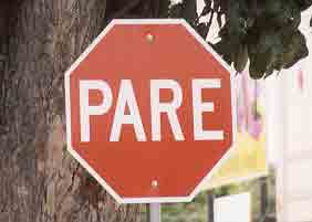
| A standard stop sign. |
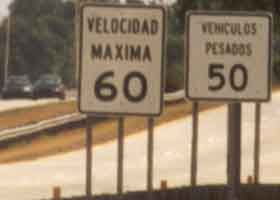
A speed limit
sign (oddly in miles per hour, even though all other road signage is metric),
with a lower truck speed limit sign alongside. While this stretch of autopista
(north end of PR-53) is posted for only 60mph, some other autopistas are
posted for 65mph. (But no free highways, even those that are controlled-access
-- apparently you have to pay for the privilege of driving over 55mph.)
|
 |
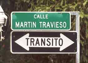 |
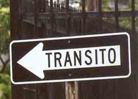
| A sign indicating
the direction of traffic on a one-way street. |
In some parts
of San Juan, so many of the streets are one-way that it is necessary to
point out the exceptions where traffic is two-way. ("Calle" means
"street.")
|
|
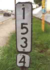
Puerto Rico uses kilometer
markers like this (or some other styles). On major routes, like here
on PR-2 in Mayaguez, tenth-kilometer markers are posted every 0.2 km. |
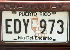
The current "Island of Enchantment" style of license plates, on my rental car. |
|
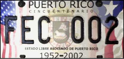 |
| Another
current license plate style, honoring the 50th anniversary of Puerto Rico's
commonweath status. (Photo from the website of Puerto Rico's Departamento
de Transportación y Obras Públicas.) |
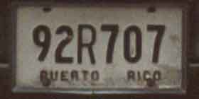
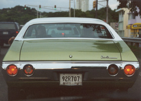
 An
older style of license plate, on a very nicely-preserved classic car I spotted in Mayaguez. An
older style of license plate, on a very nicely-preserved classic car I spotted in Mayaguez.
|
 |
|
 |
Back to Hawaii Highways site
Questions, comments? Please e-mail me.
© Oscar Voss 2002-03, 2005. |